

EFFORTS

EFFORTS (Europen Flood Forecasting Operational Real-Time System) is a decision support system (DSS) with a user-friendly GIS interface for real-time environmental monitoring and flood forecasting.
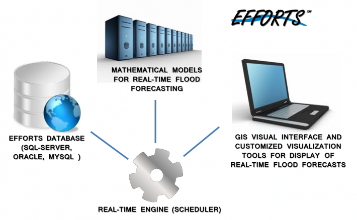
EFFORTS system has been developed especially to satisfy Civil Protection Organizations needs:
- Automatically receive real-time data from different sources and different formats (precipitation, temperature, flow, river stage, RADAR, NWP models, etc.)
- Validate and process data according to the required time step
- Store raw and sampled data into the hydro-meteorological database
- Manage flood forecasting models run (scheduler)
- Display data and models forecasts
The system runs in a completely automatic way: each time new data arrive to the system, it automatically processes them, runs models and show flood forecasting results. The User is not required to perform any action and can concentrate on analyzing data and results for taking the best decision.
|
VIDEO: |
BROCHURE: | TECHNICAL DOCUMENTATION: | PURCHASE: |
|
|
|
|
MAIN COMPONENTS
GIS-BASED VISUAL INTERFACE
The EFFORTS system is a GIS-based tool. It allows geo-referenced display of maps and information. Maps are organized in layers, each of which can be displayed alone or it can be superimposed to others.
GIS tools are available for selecting stations and getting information.